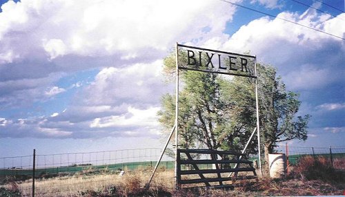
Bixler Cemetery
Seward County, Kansas
Bixler Cemetery is located outside of Liberal. Turn off hiway 54 onto Blue Bell
Road and continue 13 miles E and the cemetery is located on the left hand side
of the blacktop on the corner of road O and U. This cemetery is small and unkept
and a metal gate is wired shut across the entrance. This cemetery is not in use
and has not been for many yrs and was started in the early 1900's. A hand drawn
map of the cemetery and notes was made many yrs ago by Margaret Jannett Long,
mother to Frank Long and in the 1920's she had helped maintain this cemetery.
I personally walked this small unkept cemetery myself April 22,2002 and recorded
the following data and added the notes and names as recorded on the hand drawn
map as well. It is stated by the Miller Mortuary that when the people who owned
this cemetery passed away, the records were lost and there is not a complete
listing of people buried here, to anyone's knowledge. In the late 1980's, the
Scout troop went out to this small cemetery and cleaned it up and located and
marked many of the unknown graves, with metal markers from Miller Mortuary. If
anyone knowing or having further info regarding this cemetery or persons buried
here, and wish to donate information, please contact
Laura Ball at so that information can be added.
This cemetery is not kept up and if visitors should stop by, please use caution
during the warm months, as snakes are frequent in this area and can be dangerous.
Some of the notes are hard to read, but are as follows when available:
Information compiled by
Laura Youtsey-Ball and
submitted 28 April 2002.

Picture of Bixler Cemtery, April 2002
Picture of Bixler Cemtery, July 2007
Old Hand Drawn Cemetery Map
Text Version of Old Hand Drawn Cemetery Map
